Dossier No. 069 — Cultural Insights — Culture Mosaic
A landscape is never just soil and stone. It is a storage device for human trauma, ritual, and triumph. Mnemonic Landscape Analysis is the forensic practice of reading the invisible layers of history etched into the physical world around us — and of understanding why those layers still shape the way we move, gather, and remember.
Part I: The Topographic Memory
Why Places Remember What People Forget
Long before cities had GPS coordinates or ceramic street plaques, humans were constructing a navigation system far more sophisticated than any map. They were embedding memory directly into the physical world. The ancient practice of loci, the so-called “method of places,” taught orators to anchor their arguments to specific rooms, doorways, and thresholds they could mentally walk through. Cicero wrote about it at length. A doorway triggered one argument; a fountain column, the next.
Dossier Continuity
This is not only a rhetorical device. Mnemonic Landscape Analysis takes that founding principle and applies it at the scale of the whole city. The street corner where the herbalist traded for three generations. The subtle rise in a suburban lawn that betrays a sealed medieval well beneath the turf. The odd diagonal cut of a road through an otherwise rational grid — each is a physical neuron carrying communal history that the community itself may no longer consciously know it holds.
The central insight of Mnemonic Landscape Analysis is uncomfortable in its simplicity: when we demolish a landmark, we do not just lose a building. We delete a neurological trigger for collective memory. Memory does not float freely in the atmosphere. It is tethered to matter — to stone, to soil, to the particular angle at which a morning shadow falls across a threshold that ten thousand people have crossed across three centuries.
This is why the study of UK culture and traditions is inseparable from a study of the built environment. The rituals still enacted in town squares, along ancient processional routes, and around market crosses are not arbitrary survivals. They are the living residue of a landscape designed, centuries ago, to hold exactly those meanings.
“Every city is a palimpsest — a manuscript that has been written, erased, and written over. The forensic analyst’s job is to make the old ink visible again.”
The Stratigraphy of Memory
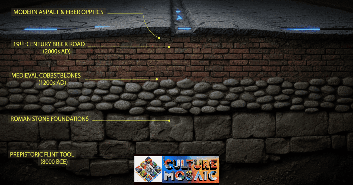
The core of Mnemonic Landscape Analysis lies in understanding that a single GPS coordinate contains thousands of years of data stacked vertically. The “Digital Infrastructure” layer we inhabit today is only the thin crust of a much deeper cultural biography. When performing an audit, analysts look specifically for “Material Succession” — places where the Roman settlement layer or the Medieval parish network forces the modern grid above it to bend, break, or deviate.
Each layer in a site’s biography represents not just a building phase but a complete social logic — a set of rules about how land should be used, by whom, and for what purpose. When those logics collide, they leave physical evidence at the surface. That evidence is the primary data of Mnemonic Landscape Analysis.
[ DIAGRAM — LOG_004: MNEMONIC STRATIGRAPHY MAP ]
[ DIAGRAM — LOG_004: MNEMONIC STRATIGRAPHY MAP ]
Caption: The reader should visually “sink” into the earth as they read downward. The highlighted strata at 7m and 12m are the primary drivers of surface-level anomalies documented in this dossier.
Forensic Marker: The “Structural Scar” — an architectural oddity proving that a previous, now-invisible structure once dictated the flow of a street or the position of a threshold.
Part II: Technical Mechanics
The Three Pillars of Mnemonic Landscape Analysis
The Forensic Framework for Reading a Place
To conduct a rigorous Mnemonic Landscape Analysis, practitioners work within three interconnected pillars. Each addresses a different register in which the past persists in the present landscape. Think of them as three instruments in the same forensic orchestra: used separately, each tells you something; used together, they produce a full picture of a place’s biographical depth.
Pillar One — Material: Palimpsest Architecture
The forensic study of buildings that have been rewritten across generations. A Roman temple becomes a Christian church, converted to a textile warehouse, now a public library. Each conversion leaves a material scar: a misaligned window, a sealed arch, a foundation running at the wrong angle to everything around it. Mnemonic Landscape Analysis calls this Material Succession — the layered biography of a structure that reveals how a society’s values have shifted, even when the original walls still stand.
Pillar Two — Behavioral: Path-Dependency Rituals
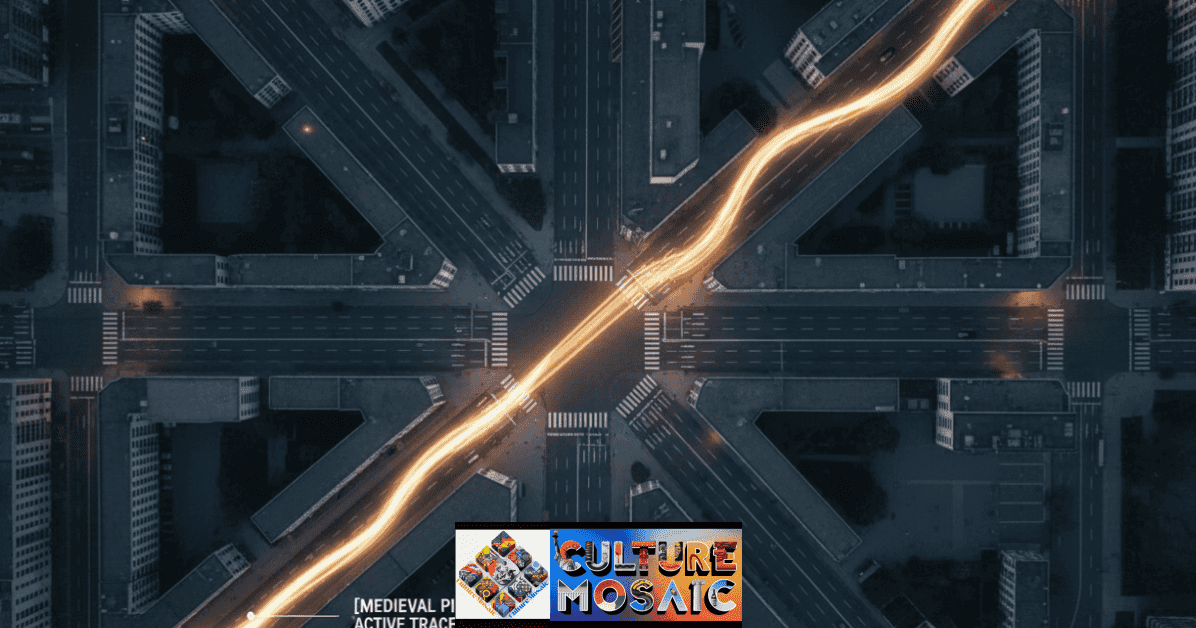
Why does a perfectly modern road suddenly curve for no logical reason? Almost always because it follows the line of a medieval field boundary, a pilgrims’ trail, or a cattle drove that was already ancient when the tarmac arrived. Cities are full of these behavioral fossils pressed into the ground. They are evidence that the proximity mechanics of shared rituals leave physical marks on a landscape long after the rituals themselves have been forgotten. The analyst reads those marks as direct testimony.
Pillar Three — Sensory: The Sensory Ghost
The most subtle pillar, and in many ways the most human. It maps the invisible heritage of a place: the specific fragrance of a spice market that closed a hundred years ago, the acoustic hollow in a plaza where a town bell once tolled, the particular quality of light in a courtyard oriented to face an equinox sunrise. The Sensory Ghost pillar of Mnemonic Landscape Analysis asks a deceptively simple question: what did this place feel like to inhabit — and why does some trace of that feeling still linger?
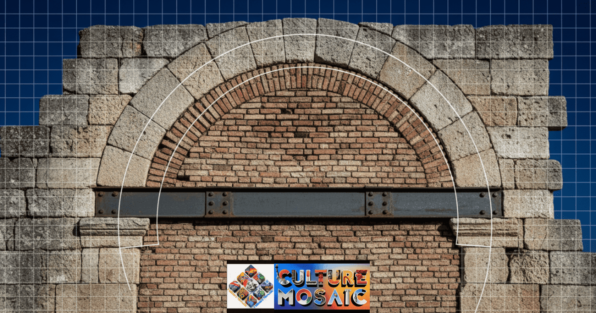
The Palimpsest City: Where Ancient Streets Meet Modern Grids
A palimpsest is a manuscript where the original text has been scraped off and written over — yet the old ink remains faintly visible through the new. In urban design, this creates the behavioral fossils described in Pillar Two. A single city block can contain four overlapping street logics from different eras. The key forensic insight is this: a modern analyst who sees only the top layer misses the entire story.
When you look at a map of any historic city and notice that the modern street grid suddenly and inexplicably curves, a forensic analyst does not see a design choice. They see a Victorian field boundary, anchored to a Roman road so physically and legally stubborn that modern pavement was forced to yield.
[ DIAGRAM — FIG. 069.B: THE PALIMPSEST CITY ]
Part III: The Landscape Forensic Audit
Conducting a Neighborhood Mnemonic Landscape Analysis
Decoding Your Neighborhood: The Mnemonic Walk
You do not need a grant or a team of archaeologists to begin your own Mnemonic Landscape Analysis. What you need is a trained eye and the willingness to ask a single question repeatedly: why does this place look exactly like this, and not some other way? The diagnostic table below is designed to accompany you on a structured walk through your own neighborhood. The key discipline is to resist the reflex to explain anomalies away. The curved road is not a planning error. The sunken lot is not waste ground. Each one is a data point.
Mnemonic Walk Diagnostic Table — Field Log 069.A
| Observation in Field | Forensic Diagnostic | Action |
| Non-logical street curve | Former boundary wall, lost water source, or old field edge. | Cross-ref tithe map |
| Ghost signage | Faded painted lettering on brick or stone. | Photograph and archive |
| Raised or sunken plot | Possible sealed well, plague pit, or sacred site. | GPR survey recommended |
| Sealed ground-level windows | Street level has risen over centuries of debris. | Document elevation delta |
| Absent feature street name | Linguistic fossil — the name outlived the structure. | Etymological log |
| Unusual acoustic softness | Sensory Ghost — echo of a lost structure or canopy. | Sound map this node |
| Misaligned building facade | Palimpsest structure — facade applied to older orientation. | Inspect rear elevation |
Palimpsest Architecture and Structural Memory
The Building as Biographical Document
The word palimpsest originally described a manuscript from which the original writing had been scraped away to make room for new text — yet traces of the old always bled through the parchment. In Mnemonic Landscape Analysis, this is the central metaphor for how buildings work across time. Almost nothing in a historic urban environment stands on genuinely virgin ground. Every site carries the memory of what stood there before.
Consider the Pantheon in Rome, the Hagia Sophia in Istanbul, or — far more ordinarily — the thousands of English parish churches that stand precisely where Iron Age temples stood. The siting is never coincidental. Sacred topography is extraordinarily persistent. Communities continue to mark the same nodes in the landscape across radically different religious systems, because those specific places carry a felt significance that predates any theology. Culture Mosaic has documented this pattern from South Asian temple complexes to pre-Christian standing stone alignments now occupied by Welsh parish churches.
What makes Mnemonic Landscape Analysis so compelling as a discipline is exactly this: it reveals that human behavior is far more conservative than we tend to believe. We think we are building new cities. In reality, we are tracing the outlines of cities that no longer exist above ground. We are laying fiber-optic cables along Roman roads. We are constructing glass towers on Neolithic hillforts. The footprint persists even when every surface material has been replaced.
The forensic analyst trains themselves to find the Material Succession seam: the exact moment where one era’s logic ends and another’s begins. It usually presents as an abrupt change in building material, a floor level that does not quite match the one beside it, or an internal wall that refuses to meet the external facade at a right angle. These are not construction errors. They are seams in time, legible to anyone who knows what they are looking for.
Part IV: The Ethics of Erasure in Mnemonic Landscape Analysis
Who Owns the Memory of the Land?
Mnemonic Landscape Analysis cannot be a neutral practice. To read a landscape forensically is to almost inevitably discover that one community’s story has been systematically written over another’s. The term for this is Mnemonic Cleansing: the intentional removal of a minority culture’s physical traces in order to rewrite the landscape’s dominant narrative without visible opposition or acknowledgment.
This is not ancient history. We need only look at the concrete numbers. In the mid-20th century, so-called “Urban Renewal” projects in the US and UK disproportionately targeted minority heritage districts, using the language of planning progress to execute what was, in forensic terms, a Memory Crime — the calculated destruction of physical triggers for a community’s collective identity.
Case Study — Baltimore, USA: The Highway to Nowhere
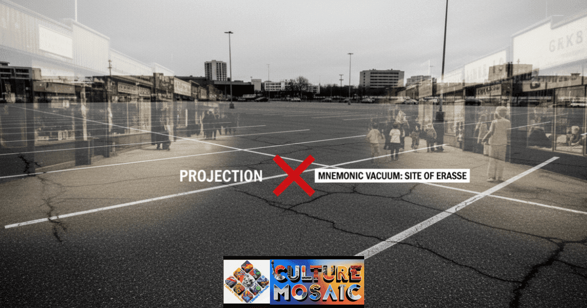
In the 1960s, the Route 40 expressway project was driven through the heart of West Baltimore’s thriving Black residential and business district. The project displaced nearly 1,500 residents and destroyed a community that had spent decades building physical mnemonic triggers: churches, business fronts, corner stores, social clubs. The landscape was not just altered. It was forensically severed. The community’s capacity to point to its own history and say this happened here was removed along with the buildings themselves.
Displaced: approximately 1,500 residents. Heritage structures demolished: hundreds.
[ DIAGRAM — FIG. 069.C: MNEMONIC CLEANSING — URBAN RENEWAL AS TOPOGRAPHIC ERASURE ]
[ FIG. 069.C ] MNEMONIC CLEANSING — COMPARATIVE SCALE OF PHYSICAL DELETION
Caption: These diagrams provide forensic proof of how planning policy was used as a tool for Mnemonic Cleansing. They illustrate the precise physical scale at which community anchors were targeted and removed.
Case Study — Tulsa, USA: The 35-Block Deletion
The 1921 destruction of Tulsa’s Greenwood district — known as “Black Wall Street” — and the subsequent postwar failure to rebuild were not simply acts of violence. They were a deliberate act of topographic erasure. A 35-block area of Black economic success was physically deleted, and the redevelopment that followed ensured the site would not easily speak its own history. Mnemonic Landscape Analysis is the tool we use to prove these stories still exist in the soil, even when the buildings are gone — and to build the evidentiary case for their recognition.
The discipline of Mnemonic Landscape Analysis intersects directly with somatic interior design principles, which operate at the scale of the private dwelling and the individual body. Where somatic design audits the private sphere of memory, Mnemonic Landscape Analysis audits the public soul of the city — who has been permitted to write it, and whose physical memory markers are being threatened right now by another planning application.
Topographic justice is the ethical imperative that follows. It means acknowledging whose stories are embedded in the ground you walk across every morning, and treating the right of those stories to remain legible as a non-negotiable civic concern — not as sentiment, not as heritage tourism, but as the basic right of communities to inhabit a landscape that reflects their history as honestly as it reflects anyone else’s.
The Mnemonic Landscape Analysis Audit Checklist
Your One-Page Guide for Urban Forensic Walks
A Mnemonic Landscape Analysis walk is not a heritage tour. You are not looking for listed buildings or tourist plaques. You are looking for inconsistencies — the places where the city’s surface story does not quite hold and something older, stranger, or more contested bleeds through. The checklist below is structured in two tiers: three primary field tasks that form the core of any audit, followed by supporting observations.
Primary Task 01 — Locate 3 Structural Scars Find three architectural oddities: misaligned facades, sealed arches, foundations at the wrong angle to everything around them. Each is a Material Succession seam — the physical boundary between one era’s logic and the next.
Primary Task 02 — Map 1 Sensory Ghost Identify one place where the sound or light feels “old” — an acoustic softness, an unexpected stillness, a quality of shadow that does not match the current architecture. Record it precisely: location, time of day, atmospheric condition.
Primary Task 03 — Identify 2 Linguistic Fossils Find two street names that no longer match physical reality. Mill Lane with no mill. Church Gate with no church. Tenter Ground with no tenter frames. Each name is a mnemonic tag outliving its referent by centuries.
Supporting Observations:
- Map all non-logical road curves and note GPS coordinates
- Photograph ghost signage: faded paint on brick or stone
- Log all raised or sunken plots of undeveloped land
- Document sealed windows or doors at sub-street level
- Note abrupt material changes within a single building
- Research pre-1900 tithe maps for your walk route
- Cross-reference the modern street grid with OS historical maps
- Interview an elder resident about lost local landmarks
- Identify any sites where community memory is actively contested
Frequently Asked Questions: Mnemonic Landscape Analysis
What exactly is Mnemonic Landscape Analysis and who uses it?
Mnemonic Landscape Analysis is a cross-disciplinary forensic method for reading the layers of human memory embedded in physical environments — streets, buildings, field patterns, and sonic conditions. It is practiced by cultural geographers, urban historians, community archaeologists, landscape architects, and civic organizations working to document heritage under threat from development. The methodology in this guide is designed so that any thoughtful person can begin practicing it, with or without formal training.
How is Mnemonic Landscape Analysis different from standard archaeology?
Archaeology typically involves physical excavation of buried material. Mnemonic Landscape Analysis works primarily with what is already visible above ground: street patterns, building fabric, naming conventions, sensory residue, and behavioral paths. It treats the living city as its excavation site, reading surface anomalies rather than digging through soil. The two disciplines are complementary — Mnemonic Landscape Analysis often identifies the sites that most warrant excavation — but they operate in fundamentally different registers.
Can I perform a Mnemonic Landscape Analysis walk in any city or town?
Yes. Towns with continuous occupation over several centuries offer the richest data, but even recently built cities carry memory traces from their earliest development phases. The practice scales to any settlement with a recorded history. The audit checklist in this guide is applicable in any urban or peri-urban environment, regardless of period or geography.
What role does ethics play in Mnemonic Landscape Analysis?
A central one. Reading a landscape forensically almost always reveals whose history has been deliberately suppressed or erased. Analysts must approach this with genuine care, particularly when working in communities where physical heritage has been targeted as part of cultural suppression. The discipline demands not only technical skill but a commitment to what practitioners call topographic justice — restoring legibility to memory that has been systematically buried or built over.
How does Mnemonic Landscape Analysis connect to collective trauma?
Very directly. Research in environmental psychology confirms that physical places function as external memory anchors for communities. When those places are destroyed, the result is not merely aesthetic loss but a genuine disruption in the community’s capacity to process and transmit its historical experience across generations. Mnemonic Landscape Analysis offers a methodology for documenting those anchors before they are lost — and in some cases, for building the evidential case for their preservation on grounds that heritage legislation alone cannot always provide.
The work of Mnemonic Landscape Analysis sits at the centre of a broader investigation being built across the Culture Mosaic dossier series. The landscape carries our collective biography — but only if we have the tools to read it and the commitment to protect what has not yet been erased. Read more at Culture Mosaic.
Further Reading from Culture Mosaic:
- Culture Mosaic Archive
- Somatic Interior Design Principles
- Proximity Mechanics of Shared Rituals
- The UK Culture and Traditions
About the Author
Dr. Mara Velde is a cultural geographer and memory studies researcher whose work focuses on the intersection of built environment, collective identity, and historical erasure. She holds a doctorate in urban cultural geography and has contributed forensic landscape analyses to conservation projects across the UK, Southern Europe, and the Middle East. She is a founding contributor to the Culture Mosaic Dossier series, where she leads the Outdoor Forensic strand examining public memory in threatened built environments.
View Full Profile and Archive →